Current Planning Scheme Amendments
Amendment C269 – Wyndham Planning Scheme Review
Background:
On Tuesday 23 April 2024 Wyndham City Council resolved to:
- Endorse the recommendations outlined in the Wyndham Planning Scheme Review 2024 – Final Report.
- Approve the Wyndham Planning Scheme Review 2024 – Final Report, to be submitted to the Minister for Planning.
- Seek authorisation from the Minister for Planning to prepare and exhibit Planning Scheme Amendment C269.
- Prepare and give notice of the amendment in accordance with the Minister’s authorisation and relevant sections of the Planning and Environment Act 1987.
- Authorise Council officers to refine the wording and the formatting and update any maps of proposed Amendment C269, and to replace any redundant wording based on any new Council or State Government policies or strategies adopted prior to exhibition of the amendment relevant to the amendment.
The amendment has received authorisation from the Minister for Planning and is now on exhibition from 25 June to 27 July 2026.
Land affected by the amendment:
The Wyndham City Council has prepared Amendment C269 to the Wyndham Planning Scheme in accordance with the ministerial authorisation letter. The amendment applies to all land within the City of Wyndham municipal boundary as it is proposing to change policies that apply across the whole municipality.
What the amendment does:
The Wyndham Planning Scheme (WPS) sets out the planning directions for the municipality and contains controls on the use and development of land to guide discretion on planning permit applications. Under the requirements of Section 12B of the Planning and Environment Act 1987, Council is required to review the WPS every four years and report its findings to the Minister for Planning.
A review has now been completed and a report has been prepared that outlines the findings. The report includes a series of recommendations for further work and for the preparation of a planning scheme amendment to update the WPS to reflect the current planning context.
As such, the amendment proposes to:
- Implement the key recommendations of the Wyndham Planning Scheme Review 2024 - Final Report. The review identified the need to update various objectives, strategies and policy documents in the Municipal Planning Strategy (MPS), Planning Policy Framework (PPF), Clause 72.08 (Background documents) and Clause 74.02 (Further strategic work). The proposed changes implement relevant new Council strategies and policies that have been adopted since the last planning scheme review in 2013 and 2018.
- Make several mapping changes to rectify anomalies, remove redundant controls, fix errors, update the name of some Government Departments referenced and align controls to be consistent with other provisions of the Wyndham Planning Scheme, as identified in the Wyndham Planning Scheme Review.
For a detailed list of all proposed changes/updates refer to Table 12 (Summary of Recommendations) of the Wyndham Planning Scheme Review 2024 - Final Report as well as the Explanatory Report.
Why is the amendment required?
The amendment is required to implement the recommendations of the Wyndham Planning Scheme Review 2024 in the Wyndham Planning Scheme.
The Review was finalised in 2024 as required by Section 12B of the Planning and Environment Act 1987. Periodic reviews ensure planning schemes provide the necessary framework to achieve a council’s land use vision for the municipality.
The Review found that the local provisions of the Wyndham Planning Scheme are generally performing well. For the most part, the Review only identified minor compliance issues, anomalies and errors when assessed against the Ministerial Direction on the Form and Content of Planning Schemes, the Practitioners Guide to Victorian Planning Schemes and relevant Practice Notes.
The Review identified a series of changes that should be made to the planning scheme, including the need to include the most recent Australian Bureau of Statistics (ABS) and other economic data in the Municipal Planning Strategy, removing redundant controls, rectifying zoning and overlay mapping issues as well as the need to include land use and development directions from adopted local and regional strategies in the Planning Policy Framework and as background documents.
Inspect the amendment:
You may inspect the Amendment, any documents that support the Amendment and the explanatory report, free of charge, at:
- the Wyndham City Council website;
- during office hours, at the office of the planning authority, Wyndham City Council, on 45 Princes Highway, Werribee, Victoria; or
- the Department of Transport and Planning website
Submissions:
The closing date for submissions is Monday 27 July 2026. A submission must be sent to the Wyndham City Council, PO Box 197, Werribee, Victoria, Australia, 3030 or via email to urbantransformation@wyndham.vic.gov.au with reference to C269wynd.
Status:
The public exhibition of the amendment is currently open and will close on Monday 27 July 2026. Following the close of the exhibition period Council will review any submissions received.
Community members who have questions about this amendment are welcome to contact the Urban Transformation Team via email at urbantransformation@wyndham.vic.gov.au
Exhibition documents:
- C269wynd Notice of Preparation of an Amendment - EXHIBITION
- C269wynd Explanatory Report - EXHIBITION
- C269wynd Instruction Sheet – EXHIBITION
- C269wynd Authorisation letter - EXHIBITION
- C269wynd Council Resolution 23 April 2024 - EXHIBITION
- C269wynd Maps – EXHIBITION
- Adopted Strategies/Policies relevant to the amendment.
- Refer to DTP Website under ‘Clauses and Schedules’ to access documents with the proposed track changes
Amendment C270wynd - Implement Wyndham Heritage Review, Stage 2 Residential Places and Precincts
Overview
The amendment proposes to implement the findings of the Wyndham Heritage Review, Stage 2 Residential Places and Precincts (Wyndham City Council, July 2025) (the Review) by applying the Heritage Overlay to 15 individual places and one heritage precinct in Werribee and Little River assessed to be of local significance.
For further details, refer to the explanatory report about the amendment.
Details of the amendment
The Wyndham City Council planning authority has prepared Amendment C270wynd to the Wyndham Planning Scheme.
The land affected by the amendment is:
- 13 Anderson Street, Werribee
- 15 Anderson Street, Werribee
- 57 Cottrell Street, Werribee
- 1 Francis Street, Werribee
- 2 Galvin Road, Werribee
- 26 Geelong Road, Werribee
- 24 Market Road, Werribee
- 13 Princes Highway, Werribee
- 23 Princes Highway, Werribee
- 1 Purcell Court, Werribee
- 112 Wedge Street, Werribee
- 8 Wyndham Street, Werribee
- 46-62 Flinders Street, Little River
- 48 Manor Road, Little River
- 60 and 80 You Yangs Road, Little River
- 4-6, 8-10 and 11-18 Beamish Street, Werribee & 3-24 and 28 Gibbons Street, Werribee
The amendment proposes to implement the Wyndham Heritage Review, Stage 2: Residential Places and Precincts (Wyndham City Council, July 2025) by applying the Heritage Overlay to fifteen (15) individual (1) heritage precinct on a permanent basis.
You may inspect the Amendment, any documents that support the amendment and the explanatory report about the amendment, free of charge, at:
- the Department of Transport and Planning website or by contacting 1800 789 386 to arrange a time to view the amendment documentation;
- the Wyndham City Council website;
- and on request, during office hours, at the office of the planning authority, Wyndham City Council, at the Civic Centre, 45 Princes Highway, Werribee.
Planning Panel report
The Planning Panel Hearing for Wyndham Planning Scheme Amendment C270wynd was held Wednesday 3 June – Friday 5 June 2026 at Planning Panels Victoria.
The Planning Panel report was issued on 6 July 2026. View panel report.
Next steps
Council will consider the Panel report and amendment at a future Council Meeting. Submitters and affected landowners will be contacted in writing when the date is confirmed, and invited to attend this meeting.
Amendment C284wynd – Implementation of the Werribee South Green Wedge Management Plan 2025
Background
On 28 October 2025, Wyndham City Council adopted the draft Werribee South Green Wedge Management Plan 2025 for public exhibition and resolved to seek authorisation from the Minister for Planning to prepare and exhibit Amendment C284wynd.
Download a copy of the Council Resolution and meeting minutes visiting Agenda of Council Meeting.
The amendment was authorised with conditions by the Minister for Planning on 7 April 2026.
Download a copy of the authorisation letter.
The amendment will be on exhibition from Thursday 21 May 2026 to Monday 22 June 2026.
About the amendment
Amendment C284wynd updates the Wyndham Planning Scheme to replace references to the Werribee South Green Wedge Policy and Management Plan (2017) with the (Draft) Werribee South Green Wedge Management Plan 2025 as a background document informing planning decision-making.
The amendment updates Clause 02.03-2 (Environmental and landscape values) within the Municipal Planning Strategy, Clause 17.04-1L (Facilitating tourism) within the Planning Policy Framework and the Schedule to Clause 72.08 (Background documents) within Operational Provisions to ensure the Planning Scheme is supported by Council’s most current and adopted Green Wedge strategic framework. The amendment also updates the Strategic Framework Plan - Map 4 at Clause 02.04 to ensure consistency with the updated background document.
The amendment supports implementation of State and local planning policy relating to Green Wedges, environmental and landscape values, agriculture and tourism.
The amendment does not rezone land, apply or remove overlays. Its purpose is to ensure the (Draft) Werribee South Green Wedge Management Plan 2025 remains current, accurate and strategically aligned with contemporary State and local policy and legislative requirements.
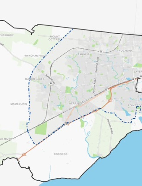
Land affected by the Amendment
The land affected by the amendment is all land in the Werribee South Green Wedge which is the area of land bound by the Port Phillip Bay coastline to the south, the Urban Growth Boundary to the north-east and the Princes Freeway to the north-west, and Little River to the west. A map showing the boundary of the Werribee South Green Wedge is included below:
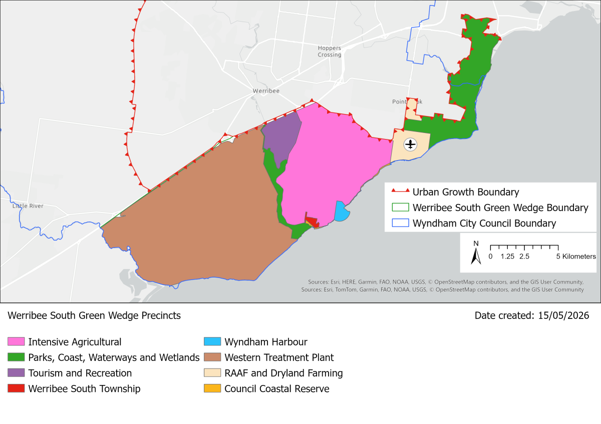
For further details, refer to the explanatory report about the amendment.
Inspect the amendment
You may inspect the amendment, any documents that support the amendment and the explanatory report about the amendment, free of charge, at:
- The Wyndham City website - see 'Exhibition Documents' below for the relevant documents attached
- During office hours, at the office of the planning authority, Wyndham City Council, 45 Princes Highway, Werribee VIC 3030 or by contacting 1300 023 411 to arrange a time to view the amendment documentation
- The Department of Transport and Planning website
Submissions
The closing date for submissions is Monday 22 June 2026. A submission must be sent to the Wyndham City Council, PO Box 197, Werribee, Victoria, Australia, 3030 or via email to mail@wyndham.vic.gov.au with reference C284wynd.
Current status
The amendment will be on exhibition from Thursday 21 May 2026 to Monday 22 June 2026. Submissions received from exhibition will be considered and confirmation of council decisions, including Planning Panel hearings will be updated on this page.
Planning Panel Hearing
In accordance with clause 4(2) of Ministerial Direction No.15 the following panel hearing dates have been pre-set for this amendment, should a panel hearing be required:
• Directions hearing: Week commencing 12 October 2026
• Panel hearing: Week commencing 9 November 2026
Exhibition Documents
- C284wynd Notice of Preparation of an Amendment Exhibition
- C284wynd Explanatory Report Exhibition
- C284wynd Instruction Sheet Exhibition
- C284wynd Council Resolution 28 October 2025 Council Meeting Exhibition
- C284wynd Council Report 28 October 2025 Council Meeting Exhibition
- C284wynd Draft Werribee South Green Wedge Management Plan 2025 28 October 2025 Council Meeting Exhibition
- C284wynd Comparison between WSGWPMP 2017 and WSGWMP 2025 28 October 2025 Council Meeting Exhibition
- C284wynd Werribee South Green Wedge Management Plan Bunurong Land Council Aboriginal Corporation Cultural Values Public Statement 28 October 2025 Council Meeting Exhibition
- C284wynd Werribee South Green Wedge Management Plan Wadawurrung Traditional Owners Aboriginal Corporation Cultural Heritage Unit Response Cultural Values Public Statement 28 October 2025 Council Meeting Exhibition
- Wyndham C284wynd Authorisation letter to PA with conditions
- Refer to DTP Website under ‘Clauses and Schedules’ to access documents with the proposed track changes
Recently Approved Planning Scheme Amendments
Amendment C231 - Various parcels in Little River, Mount Cottrell, Manor Lakes, Point Cook, Tarneit, Truganina, Werribee, and Wyndham Vale
Exhibition
The Amendment was publicly exhibited between 28 January and 1 March 2021. Notification was published in the Victorian Government Gazette, Star Weekly, and sent to all directly affected landowners and occupiers, as well as the relevant authorities in accordance with Section 19 of the Act.
During the exhibition of the Amendment, Council received a handful of enquiries, and five submissions.
Current Status:
Following a public exhibition of the Amendment C231wynd, Council considered all relevant submissions.
In the Ordinary Council meeting on 22 March 2022, Council resolved to adopt the Amendment as exhibited, except for the following changes, and to submit the adopted Amendment to the Minister for Planning for approval:
- remove the proposed Incorporated Plan Overlay Schedule 3 (IPO3) from 2 Dukelows Road, Mount Cottrell and all land within the future Oakbank PSP area;
- remove the proposed rezoning of 330 Point Cook Road to Public Use Zone 1
Background
In 2018, Council undertook a review of the Wyndham Planning Scheme pursuant to the requirement set out in Section 12B of the Planning and Environment Act 1987 (“the Act”). On 5 February 2019, Council resolved to endorse the Wyndham Planning Scheme Review Final Report, August 2018 (“the Review”), to submit the Review to the Minister for Planning, and to seek authorisation from the Minister to implement the relevant recommendations in the Review through Amendment C231wynd to the Wyndham Planning Scheme.
Due to the concurrent Smart Planning initiative of the State Government that would result in changes to many of the same provisions that were recommended for updates in the Review, the Minister restricted the scope of the Amendment to mapping changes only in their authorisation to Council on 4 December 2020. The Department of Environment, Land, Water and Planning (DELWP) advised that, all changes to the ordinance, including the Local Planning Policy Framework (LPPF) and local provisions within the Planning Scheme, should be pursued after the translation of the Planning Policy Framework (PPF). The translation has recently been completed through the approval of Planning Scheme Amendment C258wynd.
Amendment C231wynd, in accordance with the Ministerial authorisation received, proposes a number of mapping changes to rectify anomalies, remove redundant controls, and align controls to ensure consistency with other provisions of the Wyndham Planning Scheme.
Specifically, the Amendment proposes the following mapping changes:
- · Ensure consistency with existing provisions of the Wyndham Planning Scheme:
- Extend Environmental Significance Overlay Schedule 2 (ESO2) to align with the Conservation Areas as identified in the Biodiversity Conservation Strategy 2013 (“the BCS”) referenced in Clause 21.03-1.
- Align Rural Conservation Zone (RCZ) mapping over the entirety of Conservation Areas 10 and 14 identified in the BCS, except where this conflicts with Public Use Zoning crossing conservation areas (and back zone the land to the underlying zones where appropriate, i.e. where the Conservation Zone no longer applies).
- Amend the mapping of Incorporated Plan Overlay Schedule 3 (IPO3) for Ballan Road Precinct Structure Plan (PSP), Westbrook PSP and Riverdale PSP to include the Conservation Area 14 as identified in the Biodiversity Conservation Strategy (2013) within these PSP boundaries.
- Amend the mapping of Incorporated Plan Overlay Schedule 4 (IPO4) for Truganina PSP and Riverdale PSP to include the entire Conservation Area 10 as identified in the BCS within these PSP boundaries.
- Rectify mapping anomalies:
- Rezone land on 330 Point Cook Road, Point Cook from Farming Zone (FZ) to Public Use Zone (PUZ1 - Service & Utility) to recognise its public land use function.
- Rezone a number of parcels in Truganina, Manor Lakes, Point Cook, Tarneit, and Werribee from General Residential Zone (GRZ) to Public Park and Recreation Zone (PPRZ) to reflect the public ownership and use of the land.
- Rezone the Public Park and Recreation Zone (PPRZ) component of the five residential properties (24, 26 & 28 Wattamolla Ave and 4 & 5 Talia Court, Werribee) to General Residential Zone (GRZ) consistent with the balance of the properties.
- Rezone part of Green Wedge Zone (GWZ) land on 470 Wests Road, Werribee to Special Use Zone Schedule 6 (SUZ6) consistent with the balance of the land.
- Rezone part of the Council reserve on 92 Willowgreen Way, Point Cook from Public Conservation and Resource Zone (PCRZ) to Public Park and Recreation Zone (PPRZ), consistent with the balance of the reserve.
- Rezone 62 Black Forest Road, Werribee from General Residential Zone Schedule 1 (GRZ1) to Urban Flood Zone (UFZ), to recognise its public ownership, flood risk, and land management practice consistent with the balance of the adjoining floodway / open space.
- Rezone the PPRZ portion of the land on 36 Manorvale Parade in Werribee (Lot 1, TP826209) to GRZ1, consistent with the balance of this privately-owned residential land.
- Realign the Heritage Overlay (HO) to cover the entire property of 51-59 Russell Street (HO89).
- Realign the HO to cover the whole - Grant Bridge on You Yangs Road, Little River (HO122).
- Extend the HO to cover the concrete building on Little River Reserve, 15-31 You Yangs Road, Little River (HO124).
- Remove redundant controls:
- Remove application of Development Plan Overlay Schedule 2 (DPO2) from 2, 8, 10, 12 Mala Street and 54A, 54B, 54C and 54D Toritta Way, Truganina.
Inspecting the amendment
You may inspect the amendment, any documents that support the amendment and the explanatory report about the amendment, free of charge, at:
- during office hours, at the office of the planning authority, Wyndham City Council, 45 Princes Highway, Werribee
- at the Department of Environment, Land, Water and Planning website www.delwp.vic.gov.au/public-inspection.
- View - C231wynd Notice
- View - C231wynd Instruction Sheet
- View - C231wynd Maps
- View - C231 Explanatory Report
Amendment C246 – Public Acquisition Overlay - 75 Westmeadow Lane, Truganina
Status
Council resolved to abandon the amendment following a resolution with the landowner to purchase the land. The Minister has now been notified of Council’s decision.
What was proposed in the amendment: The Amendment proposed to apply a Public Acquisition Overlay (PAO3) to the land located at 75 Westmeadows Lane, Truganina
Why was the Amendment proposed initially?
The Amendment was proposed to identify the land as required for an active open space reserve. This responds to a documented current and future shortfall of active open space in the north of the municipality, as identified in the Wyndham Open Space Strategy (WOSS), a strategy adopted by Council with a purpose “intended to address open space needs of the existing Wyndham community and plan for the future growth by anticipating the needs of the growing population”.
The WOSS identifies a current shortfall in district level active open space across the north of the municipality, in the suburbs of Tarneit, Hoppers Crossing and Truganina. The WOSS states that across the three suburbs, there is a collective deficit of 40.2 hectares of district level active open space.
Currently there are very limited opportunities to provide for additional active open space to meet the identified shortfall in the existing developed areas of Hoppers Crossing and Truganina.
The land affected by the amendment is non-developed land of a size that can facilitate development of active open space that would service the Truganina/Hoppers Crossing area.
The WOSS recommends as a key action the need to secure and develop new active open spaces in the established suburbs of Wyndham to cater to the sporting demands of the current and growing population. Recommended actions for the provision of active open space include:
“Identify sites to improve the coverage of district level active open spaces to serve the following OSPDs as priority: Point Cook, Tarneit and Hoppers Crossing.” (Action no. 10)
The proposal responds to the need identified in the WOSS Acquisition Plan (Appendix 4, Page 172) to secure district level active open space given the shortfalls of 21.98ha in Hoppers Crossing, 3.46ha in Tarneit and 14.78ha in Truganina, Williams Landing, Laverton North when compared to open space coverage standards identified in the WOSS. The land identified in this Amendment is located close to the boundary of the Hoppers Crossing, Tarneit and Truganina Open Space Planning Districts.
The exhibition process:
The proposed Amendment was formally put on public exhibition between 30 March 2020 and 14 May 2020. Council received one submission against the amendment.
Why was the amendment abandoned:
In parallel to the exhibition process, Council officers entered discussions and worked to negotiate with the landowner for the private purchase of the land. In 2021, the landowner agreed to the private sale of the land to Council and a contract was finalized in December 2021. As a result, the Amendment which would facilitate a compulsory acquisition is no longer required and should be abandoned.
Where you may inspect this Amendment
The abandoned Amendment is available for public inspection, free of charge, at the front entrance of Wyndham City Council, 45 Princes Highway Werribee. The amendment is also available below (See links below).
Links:
Amendment C253WYND/ WYP11874/19 - Combined amendment/permit application - 420 Wests Road, Werribee
The land affected by the combined amendment / planning permit is Lot 3 of TP319902, on 420 Wests Road, Werribee.
The Amendment proposes to insert a new Schedule 5 to the Clause 37.01 Special Use Zone and rezone the land from Schedule 6 to the Special Use Zone to Schedule 5 to the Special Use Zone. The application is for a permit to allow the use and development of the land for a concrete batching plant.
The applicant for the permit is Holcim (Australia) Pty Ltd.
Inspect the amendment:
You may inspect the Amendment, the Explanatory Report about the Amendment, the application, and any documents that support the Amendment and the application, including the proposed permit, free of charge, at:
- the Wyndham City Council website at www.wyndham.vic.gov.au; and
- during office hours, at the office of the planning authority, Wyndham City Council, on 45 Princes Highway, Werribee, Victoria.
- at the Department of Environment, Land, Water and Planning website www.delwp.vic.gov.au/public-inspection.
Status:
The public exhibition of the amendment closed on 2 July 2021. Council is reviewing the submissions received. With further work to be undertaken by the proponent, Council is anticipated to formally consider the amendment before the end of this year.
Community members who have questions about this amendment are welcome to contact Urban Futures at Council.
Exhibition documents
C253wynd 001znMap21 Exhibition
C253wynd Explanatory Report Exhibition
C253wynd Instruction Sheet Exhibition
C253wynd WYP11874_19 Draft Permit Exhibition
Amendment C260wynd – Amendment to Tarneit North PSP (Widening of Dohertys Road)
Background:
On Tuesday 9 February 2021 Wyndham City Council Planning Committee resolved to
1. request the Minister for Planning to:
a) prepare Amendment C251wynd, and exempt themself from any of the requirements of sections 17, 18 and 19 and the regulations, under Section 20(4) of the Act;
b) approve Amendment C251wynd;
2. in the event where the Minister does not undertake amendment C251wynd as per recommendation (1) above, authorise officers to proceed to seek authorisation from the Minister to prepare and exhibit the amendment in accordance with any conditions as directed by the Minister.
Note: Amendment C251wynd has been changed to Amendment C260wynd
Download a copy of the Council Resolution and meeting minutes.
The amendment has received authorisation from the Minister for Planning and is now on exhibition.
Purpose of Amendment
The purpose of the amendment is to address an anomaly in the Tarneit North PSP incorporated document to ensure sufficient land is allocated on the three properties identified below to make provision for the 66kV overhead powerlines (and associated landscaping). These properties include:
• 560 Davis Road Tarneit
• 1283 Dohertys Road, Tarneit
• 1273 Dohertys Road, Tarneit
What the Amendment does
The Amendment updates the content of the Tarneit North Precinct Structure Plan incorporated document and Wyndham North Development Contributions Plan Incorporated Document.
Inspect the amendment:
You may inspect the Amendment, any documents that support the Amendment and the explanatory report, free of charge, at:
- the Wyndham City Council website at https://www.wyndham.vic.gov.au/services/building-planning/planning-sche…;
- and during office hours, at the office of the planning authority, Wyndham City Council, on 45 Princes Highway, Werribee, Victoria.
- at the Department of Environment, Land, Water and Planning website https://www.planning.vic.gov.au/schemes-and-amendments/amending-a-plann….
Submissions
Any person who may be affected by the amendment may make a submission to the planning authority. Submissions about the amendment must be received by 27 November 2023.
A submission must be sent to (with reference to Amendment C260wnd):
Wyndham City Council
Civic Centre
45 Princes Highway
Werribee VIC 3030
OR
Exhibition documents
Notice of preparation of an amendment
Explanatory Report
Tarneit North PSP (amended August 2023)
Wyndham North DCP (amended August 2023)
Wyndham North DCP Appendices (amended August 2023)
Amendment C265 - Tarneit North PSP
UPDATE – Please be advised that at the 23 April 2024 Council Meeting, Council resolved to:
- Abandon Amendment C265wynd and notify the Minister for Planning in writing and publish a notice of the decision, pursuant to Section 28 of the Planning and Environment Act 1987.
- Requests officers to prepare a new piece of work to address housing density and diversity issues around the Regional Rail Link Stations that seeks to align planning and development outcomes with The Wyndham Plan.
- Note that this new piece of work may ultimately form the basis for a new planning scheme amendment, subject to a future decision of Council.
Please see notice of decision to abandon amendment here.
Background:
On Tuesday 8 November 2022 Wyndham City Council resolved to
- Seek authorisation from the Minister for Planning for Council to prepare a Planning Scheme Amendment to the Wyndham Planning Scheme to amend the Tarneit North PSP to support and encourage an increase in housing densities within 400 metres of the future Davis Road railway station.
- Prepare and give notice of the amendment in accordance with the Minister’s authorisation and relevant sections of the Planning and Environment Act 1987.
- Download a copy of the Council Resolution and meeting minutes.
The amendment has received authorisation from the Minister for Planning and is now on exhibition.
Land affected by the amendment:
The Wyndham City Council has prepared Amendment C265 to the Wyndham Planning Scheme in accordance with the ministerial authorisation letter. The land affected by the amendment is within the Tarneit North PSP and within 400 m of future railway station sites and any future Principal Public Transport Network (PPTN).
What the amendment does:
The amendment seeks to provide stronger guidance in the Tarneit North PSP to achieve density and housing diversity in in locations supported by existing and future transport infrastructure.
Specifically, the amendment proposes to:
1. Update Requirement 7 in the Tarneit North PSP.
Requirement 7 currently states:
"Development must appropriately respond to the existing railway station, potential future railway station sites, and future Principal Public Transport Network (PPTN) through the creation of opportunities for high density residential development."
Proposed wording of Requirement 7:
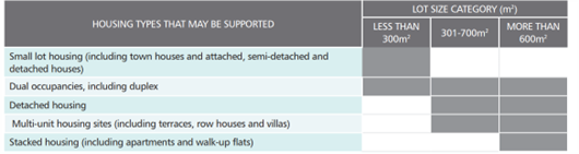
"Development within 400m of the existing railway station, potential future railway station sites, and any future Principal Public Transport Network (PPTN) must provide an appropriate response through the creation of opportunities for high density residential development, particularly stacked housing as defined in Table 1 and as described in the concept plans in Section 3.2.
Table 1 of Section 3.1.2 is reproduced below.
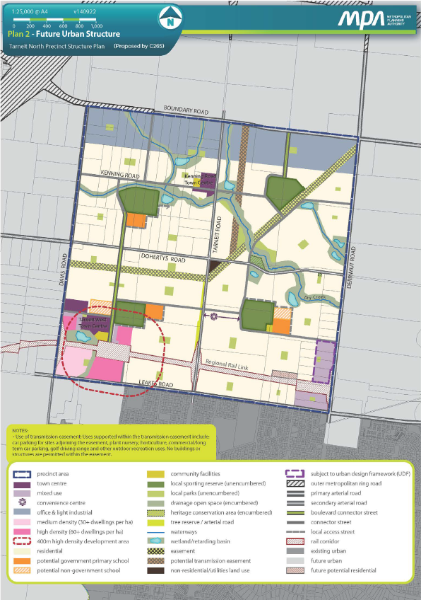
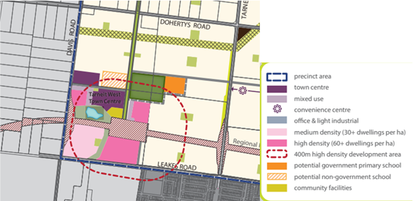
2. Update plans 2 and 3 within the Tarneit North PSP
The amendment proposes to replace the existing Future Urban Structure Plan and Image, Character, Heritage, & Housing Plan (i.e. Plan 2 and Plan 3 in the Tarneit North PSP) with updated plans including the changes shown in Figure 2 below:
3. Amend Schedule 13 to Clause 37.07 (Urban Growth Zone)
The amendment proposes to revise Schedule 13 to the Urban Growth Zone to include an updated Plan 1 showing higher density areas within 400 m of the future Davis Road Railway Station (identical to Figure 2 above).
4. Amend the Schedule to Clause 72.04 (Incorporated Documents)
The amendment proposes to introduce a revised schedule to Clause 72.04 to update the document date for the Tarneit North PSP to reflect the date of this amendment.
Inspect the amendment:
You may inspect the Amendment, any documents that support the Amendment and the explanatory report, free of charge, at:
- the Wyndham City Council website at https://www.wyndham.vic.gov.au/services/building-planning/planning-scheme-amendments/current-planning-scheme-amendments; and
- during office hours, at the office of the planning authority, Wyndham City Council, on 45 Princes Highway, Werribee, Victoria.
- at the Department of Environment, Land, Water and Planning website https://www.planning.vic.gov.au/schemes-and-amendments/amending-a-planning-scheme/planning-documents-on-exhibition.
Status:
The public exhibition of the amendment closed on 7 August 2023. At the 23 April 2024 Council Meeting, Council resolved to abandon Planning Scheme Amendment C265. Please see notice of decision to abandon amendment here.
Community members who have questions about this amendment are welcome to contact Urban Transformation at Council.
Exhibition documents:
- C265wynd Explanatory Report – EXHIBITION FINAL
- C265wynd Instruction Sheet – EXHIBITION FINAL
- C265wynd Tarneit North PSP – VPA Updated Document – EXHIBITION FINAL
- C265 - Notice of Decision to abandon amendment - FINAL.pdf
- C265wynd Map of Land Affected - EXHIBITION FINAL (see map above)
Amendment C266wynd - Implementation of The Wyndham Plan 2025
About the amendment
The amendment updates the Municipal Planning Strategy (MPS) to implement The Wyndham Plan (Wyndham City Council, 2025) and to provide a strategic framework to guide future development within the City of Wyndham.
The amendment also updates the Schedule to Clause 74.02 (Further Strategic Work) to include future actions to be undertaken by Council which have been derived from The Wyndham Plan (Wyndham City Council, 2025).
The land affected by the amendment is all land within the municipality of Wyndham.
For further details, refer to the explanatory report about the amendment.
Details and documents
For more details and documents that support the amendment and the explanatory report about Amendment C266wynd.
Amendment C267 - Implementation of the Wyndham Industrial Land Use Strategy
UPDATE – Please be advised that the Minister for Planning published a notice of approval for planning scheme amendment C267wynd in the Special Government Gazette on Friday 12 December 2025.
Find out more by visiting the Government Gazette website.
Background:
On Tuesday 9 May 2023 Wyndham City Council resolved to
- Seek authorisation from the Minister for Planning to prepare and exhibit Planning Scheme Amendment C267.
- Prepare and give notice of the amendment in accordance with the Minister’s authorisation and relevant sections of the Planning and Environment Act 1987.
Download a copy of the Council Resolution and meeting minutes visiting Agenda of Council Meeting
The amendment has received authorisation from the Minister for Planning and is now on exhibition from 1 February to 3 March 2024.
Download a copy of the authorisation letter
Land affected by the amendment:
The Wyndham City Council has prepared Amendment C267 to the Wyndham Planning Scheme in accordance with the ministerial authorisation letter. The amendment applies to current and future industrial zoned land within the City of Wyndham municipal boundary.
What the amendment does:
The amendment will ensure that the Wyndham Industrial Land Use Strategy (WILUS) is considered in all future policy and strategic initiatives as a relevant background document and that the strategy objectives are reflected appropriately in local policy in the Wyndham Planning Scheme. This will enable Wyndham to effectively plan and meet the growing demand for industrial land and the economic and employment opportunities that this will provide.
Specifically, the amendment will:
- Insert the Wyndham Industrial Land-Use Strategy 2022 (WILUS) into the Wyndham Planning Scheme as a background document in the Schedule to Clause 72.08.
- Amend the relevant sections of the Municipal Planning Strategy at Clause 02.03-7 (Economic Development) and also at Clause 02.04 (Strategic Framework Plan) to include a new map showing the Wyndham City Industrial Precincts.
- Amend local planning policy at Clause 17.03-1L to reference and align with the WILUS.
- Amend the Schedule to Clause 74.02 (Further Strategic Work) to include further strategic work as identified in the WILUS.
Inspect the amendment:
You may inspect the Amendment, any documents that support the Amendment and the explanatory report, free of charge, at:
- the Wyndham City Council website and
- during office hours, at the office of the planning authority, Wyndham City Council, on 45 Princes Highway, Werribee, Victoria.
- at the Department of Transport and Planning website
Status:
The exhibition period for Amendment C267 has now closed.
The amendment was publicly exhibited from 1 February to 3 March 2024.
The Minister for Planning published a notice of approval for planning scheme amendment C267wynd in the Special Government Gazette on Friday 12 December 2025.
The approved and gazetted version of the amendment documents can be viewed on the Department of Transport and Planning website.
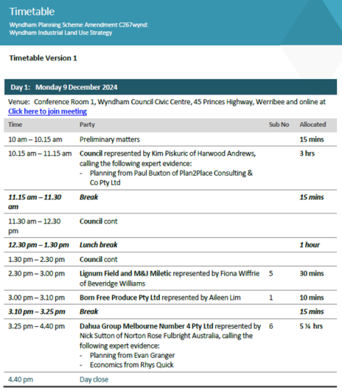
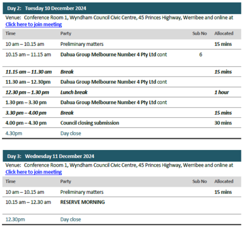
Planning Panels Victoria Hearing
The Planning Panels Victoria Hearing for Wyndham Planning Scheme Amendment C267wynd will be held on Monday 9 to Tuesday 10 December 2024 from 10 am each day, in person and by video conference.
Venue: Conference Room 1, Wyndham Council Civic Centre, 45 Princes Highway, Werribee and online at Click here to join meeting
Note: there is a reserve half day on Wednesday 11th December 2024 from 10 am to 12:30 pm. The Panel will advise on the Tuesday the 10th of December if this day is required.
Parties to the Hearing have been contacted by Planning Panels Victoria regarding these arrangements. The Panel will hear this matter in an open forum, consistent with its obligation to conduct hearings in public.
To observe proceedings, you can access the video conference using the above link.
If you have any questions, please contact Planning Panels Victoria at planning.panels@transport.vic.gov.au
Please be advised that the Hearing must not be recorded in any part or in any way without permission from the Panel. This includes audio and video recording.
Please see proposed Amendment C267 Planning Panel Hearing Timetable below:
Panel Report
A final Planning Panel Report was released by the Panel Members on 20 December, 2024. Download a copy of the Panel Report.
On Tuesday 25 March 2025 Wyndham City Council resolved to:
- Adopt Planning Scheme Amendment C267wynd with minor changes as recommended by the Panel Report received by Council on 20 December 2024.
- Submit the amendment to the Minister for Planning for approval and Gazettal in accordance with the Planning and Environment Act 1987.
- Prepare a graphic redesign of the WILUS document prior to submitting the Amendment to the Minister for Planning as supported by the Panel Report.
Download a copy of the Council Resolution and meeting minutes.
Exhibition documents:
- C267wynd Explanatory Report – GAZETTED
- C267wynd Instruction Sheet – GAZETTED
- C267wynd Clause 02.03 Strategic Direction – GAZETTED
- C267wynd Clause 02.04 Strategic Framework Plan – GAZETTED
- C267wynd Clause 17.03-1L Industry – GAZETTED
- C267wynd Schedule to Clause 72.08 Background documents – GAZETTED
- C267wynd Schedule to Clause 74.02 Further strategic work – GAZETTED
- C267wynd Wyndham Industrial Land-Use Strategy (Wyndham City Council, 2025) – GAZETTED