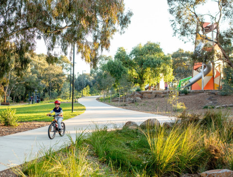
Whether you are travelling to work or school, or just looking for a great leisure experience, Wyndham has many bike trails and walking paths for you to explore.
Walking is one of the easiest ways to be active, keeping you healthy and happy, and best of all it’s free! Aim for 30 minutes a day (in at least 10 minute blocks) and you can reduce the risk of many health issues including heart disease, stroke, and Type 2 diabetes. Walking can help achieve a healthier weight, maintain bone density, improve balance and coordination, reduce stress and improve your mood.
Many of the trails connect to other paths and points of interest, including the Federation Trail which takes you to Brooklyn where you can continue to Melbourne.
Tips for all shared path users:
- Keep left unless overtaking.
- Think safe - be considerate of others and give way to other path users.
- If riding a bike keep to an appropriate speed (20 to 25 km/hr max), when passing slow down, ring your bell gently and call ‘passing’.
- Move off the path if you are stopping.
- Visit VicRoads’ Cyclist Safety webpage for advice on riding safely and responsibly.
- Find out about road rules on VicRoads’ Bicycle Road Rules webpage
Map showing key paths for pedestrians and cyclists
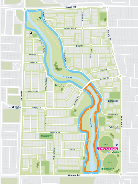
Davis Creek Active Path (Tarneit)
Two shared paths for you to enjoy.
Long Course is 4.2km marked in Blue, Short Course is 2.2km marked in Orange
Both looped paths start on the footpath next to Wootten Rd Reserve and run beside Davis Creek.
This is a shared footpath so please be mindful of other users and keep to the left.
Werribee River Trail (Werribee and Tarneit)
Werribee River Bike Trail winds alongside the Werribee River from Presidents Park in Wyndham Vale to the Princes Freeway, Werribee.
This is a shared trail so keep your eye out for pedestrians and the Saturday morning Park Run at Presidents Park.
You can start your journey at many entry points along the trail, including the Werribee Train Station.
The Werribee Rive Trail has three main sections:
Presidents Park in Wyndham Vale travelling north to Tarneit along Davis Creek
The paths around Presidents Park are about 2km and the perfect place for learner riders.
For a longer ride, cross the river at the ‘Shaw’s Road Bridge’ and head north along the Werribee River to Tarneit, connecting to the Davis Creek Trail.
From Presidents Park you can also connect to the pathways in Wyndham Vale, via the flood way path. Access is between the skate park and dog obedience club.
Presidents Park in Wyndham Vale travelling south to Cottrell St, Werribee
With the trail along both sides of the Werribee River this is the perfect 5km loop or an easy and scenic 2.5km in one direction.
Car parking is at the Off-Lead dog park at Presidents Park.
Werribee CBD to Princes Freeway, Werribee.
This part of the trail takes you into Werribee City Centre, through Wyndham Park and past Chirnside Park. Head into one of the many cafes in Watton Street to refuel or take a break in the park.
Between Chirnside Park and the Princess Freeway there are several quiet places to rest and watch the riverbank. This is the section of the river that you would be most likely to sight the elusive Platypus.
If you want some local history, some sights along this trail are signed with both indigenous and early pastoralist history.
At the Princess Freeway end of the trail you have two options: to connect to the Federation Trail or continue your journey into the Werribee River Park and Werribee Park Precinct (Werribee Park Mansion and Werribee Open Range Zoo). The section of the trail which goes under the freeway is unmade, cyclists will need to dismount and walk their bikes.
Wyndham Bay Trail (Werribee South)
Werribee South is a popular destination for locals and visitors.
The Wyndham Bay Trail is a paved scenic route along the Werribee South Foreshore, Port Phillip Bay, ending at Wyndham Harbour. The trail is 2.5km each way.
Start your journey from the Werribee South Beach carpark. This is where the Werribee River meets Port Phillip Bay and a perfect place to explore, here you will find:
- One of the most popular boat ramps in the bay
- A children’s playground with BBQ’s
- A small jetty for fishing
- Enough open space to fly a kite
There is an abundance of bird life along this trail, especially Pelicans who like to check out the fisherman’s catch at the end of the day. Across the road is Anglers Anchorage ‘a popular spot for take away coffee or fish & chips - a local favourite’.
Federation Bike Trail (Werribee, Hoppers Crossing and Point Cook)
Path Updates: The Federation Trail has been upgraded to transform it into a new concrete path including new solar path lighting, line marking, cycle repair stations. Council are planting more trees and completing landscaping works to transform the Main Outfall Sewer (MOS) Reserve into a new linear park. Ongoing works to the MOS Reserve may impact your journey via the Federation Trail visit the Greening the Pipeline Major Project page for information.
The Federation Trail is a safe off-road, sealed path for pedestrians and cyclists, linking Werribee and Brooklyn. The 24 km trail passes through Brimbank, Hobsons Bay and Wyndham. It will take most cyclists between 1 to 2 hours (in each direction).
The trail mostly follows the historic reservation of the Main Outfall Sewer (MOS) and passes through the Williams Landing Parkland and community garden.
- The path crosses the aqueduct over Skeleton Creek, then travels south along Skeleton Creek reserve.
- Then passes under the Melbourne-Geelong rail line and follows the rail reserve towards Hoppers Lane.
- The path continues along Hoppers Lane before reconnecting with the MOS reserve next to the Princes Freeway at the Maltby Bypass.
- Then continues along the northern side of the freeway before crossing Duncans Road at a signalised intersection, and follows the path underneath the large cypress trees until it reaches the Werribee River.
- At the Werribee River connect to head north along the Werribee River Trail. Cross the bridge to the Werribee River Park Trail (and into Werribee Park Precinct)
- Or for experienced cyclists join the Princes Freeway and ride towards Geelong.
The trail is well marked on Google maps.
Heathdale/Glen Orden Wetlands Bike Trail (Werribee and Hoppers Crossing)
This easy 3.3km trail winds down via Cambridge Primary School through Cambridge Reserve to Derrimut Road, Hoppers Crossing and back.
You will pass the Heathdale Glen Orden Wetlands (popular for bird watching) along the way. It is worth taking a short detour to circle the wetlands.
This is an easy flat ride, popular with families because it is all off road, and there are plenty of places to play and explore along the way.
To continue further along the trail, cross Derrimut Road and follow the drainage reserve to the Princes Highway, where you can link up to the Federation Trail.
Lollypop Creek Bike Trail (Wyndham Vale)
Lollypop Creek flows through Wyndham Vale, and the bike trail follows the creek through the residential areas and past sporting reserves.
There are many areas you can enter the trail. Start at Wyndham Vale Reserve and head north across Greens Road along to Armstrong Road.
Past Armstrong Road the path continues along the creek through the newly established suburbs at Manor Lakes past small wetlands and parks.
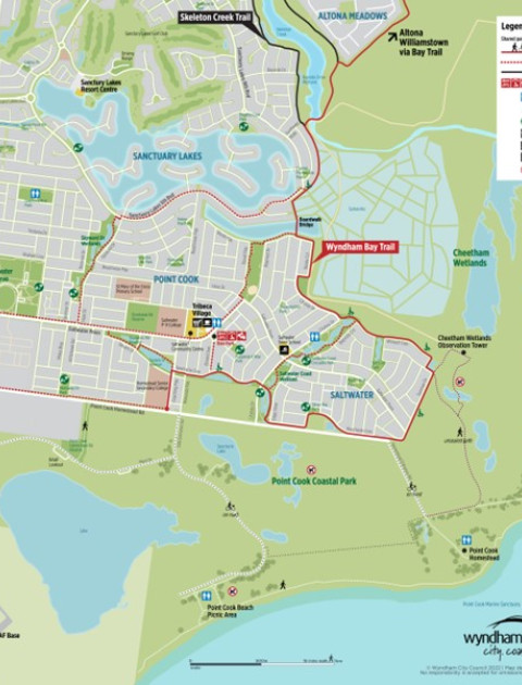
Point Cook Shared Path Network
The network includes many shared paths and suggested routes including links to the Wyndham Bay Trail, which runs from Hobsons Bay to Point Cook Coastal Park.
Directional (wayfinding) signs and maps located in Point Cook show shared paths, trails, destinations and amenities.
Sanctuary Lakes South Boulevard and Saltwater Coast Estate boardwalk connects the northern and southern sections of the Bay Trail. The 21km Bay Trail (marked in red in the first map) connects to Altona and Williamstown beach foreshores and passes through wetlands including: Cheetham Wetlands, Truganina Park, Altona Coastal Park, and Jawbone Conservation Reserve.
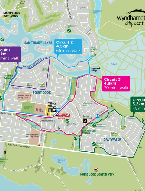
The second map has 4 different circular routes, ranging from 2.2km to 4.5km.
Please remember to keep to the left and respect other path users.
Skeleton Creek (Tarneit, Hoppers Crossing and Point Cook)
Please note: The Federation Trail has been upgraded to transform it into a new concrete path including solar path lighting, line marking, cycle repair stations. Council are planting more trees and completing landscaping works to transform the Main Outfall Sewer (MOS) Reserve into a new linear park. Ongoing works to the MOS Reserve may impact your journey via the Federation Trail visit the Greening the Pipeline Major Project page for information.
The Skeleton Creek Trail consists of two sections.
Section one: Leakes Road, Tarneit to the Viaduct
- Passes through residential estates heading south to Old Geelong Road.
- There are many entry points.
- This section connects to the Federation Trail at the Viaduct before Old Geelong Road.
Section Two: South of the Princes Freeway
- Starts at Boardwalk Estate, Point Cook, running along both sides of Skeleton Creek to the Cheetham Wetlands.
- You will travel through Point Cook, Seabrook and Sanctuary Lakes.
- Just before the Cheetham Wetlands there is a bridge to cross the creek and head to Altona Meadows. You can connect to the Bay Trail here.
- Along the creek are sites of significance to Indigenous people, wetland areas as well as remnants of an old bluestone dairy.
Victoria Walks
Create, discover and share walks wherever you live, work and play.
Victoria Walking maps will excite and inspire you to explore what is at your own doorstep, take a scenic stroll around premier tourist destinations or schedule a 30-minute walking meeting around your workplace.
Werribee River Walks
- Riverbend Park to Davis Creek, Tarneit: Wander along the Werribee River to the wetlands and billabongs of Davis Creek, 3 km each way.
- Werribee to Riverbend Park loop: Tranquil scenery, ancient red gums, market gardens and historical markers, 8.2 km loop following the bends of the riverbanks.
- Wyndham Park loop: A 2.6 km loop from the fantastic Wyndham Park to Bungies Hole.
- Werribee River Park, Cocoroc: 2.6 km loop taking in escarpment views, the historic bluestone ford and peaceful red gum bushland. Werribee Open Range Zoo and Victoria State Rose Garden are located close to this walk.
- K Road Cliffs, Werribee South: A short but spectacular walk to view the dramatic red cliffs rising above the Werribee River, 600m return.
- Urban hike along the Werribee River: Stretch your legs along 8.5 km of continuous riverside pathways in central Werribee (17 km return).
- Wyndham Bay Trail to Werribee South Foreshore: A bayside stroll from ultra-modern Wyndham Harbour to the river estuary at Werribee South Beach, 2.5 km one way, 5 km return.
Skeleton Creek and Cheetham Wetland Walks
- Skeleton Waterholes Creek, Tarneit and Truganina: An excellent walk for connecting to nature along Skeleton Waterholes Creek and Tarneit Creek. 5 km loop
- Skeleton Creek from grasslands to wetlands: Follow Skeleton Creek Trail from Bruce Comben Reserve, Altona Meadows to Cheetham Wetlands and back on the Point Cook side of the creek. 7 km loop
- Cheetham Wetlands tower walk, Point Cook: Explore the wetlands and salt marshes from the boardwalks and observation tower at Cheetham Wetlands in Point Cook. 3 km loop.
Lollypop Creek Walk
- Lollypop Creek Trail, Wyndham Vale: Elevated boardwalks open this 4.4km loop walk along the creek and wetlands. This section of the Lollypop Creek Trail leads to the spectacular and serene Tucker's Waterhole.
To find out more visit Walking Maps.
Walking Groups
For social connection and a guided walk through your local area, why not join one of Wyndham’s free organised Walking Groups. These groups usually accommodate all speeds of walking with lead and tail walking guides, however please confirm all details with the group organiser before joining.
To list your walking group, please send all relevant walk and contact details to activewyndham@wyndham.vic.gov.au
Werribee River Rovers
Group Organiser: Michael Poswiat, misiu31@gmail.com
Walk time: Weekly, Thursdays 10:00 am
Meeting point: Rotating between the end of Watton Street Werribee, Werribee Mansion area and Werribee South. Walkers are notified of the location every week by email.
Duration of walk: 45-60 minutes (this walk is listed as ‘medium pace’)
Iramoo Strollers
Group Organiser: Iramoo Community Centre, 8742 3688, admin@iramoocc.com.au
Walk time: Weekly, Thursdays 9:30 am
Meeting point: Iramoo Community Centre, 84 Honour Avenue Wyndham Vale
Duration of walk: 30-40 minutes
Point Cook Activity Group
Group Organiser: Bev Morrissey, 0417 324 489, tombevm@gmail.com
Walk time: Every weekday, 9:00 am
Meeting point: Outside AUS Drycleaning at Point Cook Shopping Centre (formerly Point Cook Town Centre), Main Street Point Cook
Duration of walk: 45-60 minutes (this walk is listed as ‘medium pace’)